The Porter Farm Homestead
Much of Kansas City’s urban reuse and revitalization activity has begun to emerge in an area just south and east of Downtown. One such area has a long and colorful history as a historic location for residential, municipal recreational amenities, vital transportation corridors and commercial development has its roots with a farm homestead established by the Reverend James Porter in 1834.
To understand the significance of this area and its contribution to the fabric of today’s urban renaissance, it helps to know when, where and how it all started.
Porter Farm
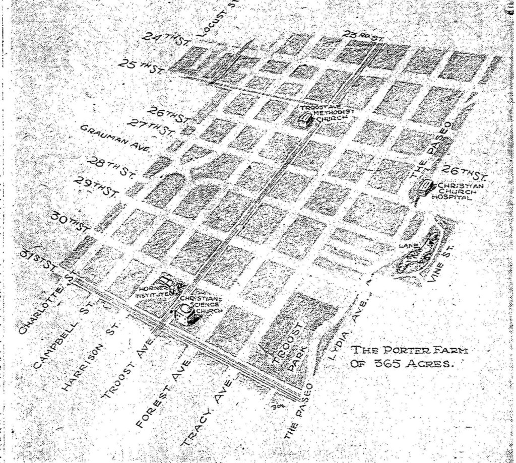
Before it was divided and subdivided, developed and redeveloped, a 365- acre area of Kansas City centered around 27th and Troost was known as the Porter Farmstead. The huge tract was the home of the Rev. James Porter family. The Porters acquired the land in 1834, established a large plantation there growing a variety of staple of fruit produce. Five generations of the Porter famlily lived in the original and subsequent iterations of farmhouse very near what is now 28th and Tracy Avenue.
The Rev. James Porter left Franklin, Tennessee in 1834, with a dream – he wanted a place in the wilderness where he could carve out space for his family and to propagate his faith. Many eastern and southern families, encouraged by liberal and inexpensive land grants by the United States government, flocked to areas in and around what is now Kansas City. It seemed perfect to Porter, “who wanted to form his own little colony in Western Missouri. 1 He set out with his wife, Jane Thomas Porter, son Jesse LaGrande Porter, his mother Elizabeth Porter, and 40 slaves. Rev. Porter bought the large tract of land by patent from the United States, which had acquired it from France as part of the Louisiana purchase.
The Porter Plantation
The Porters, or more likely their slaves, built a five-room log home (later enlarged) between 27th and 28th east of Tracy facing north. It was constructed of black walnut logs and black walnut weather boarding. To the rear of the home were the slave cabins.
The plantation had a natural water supply, a spring at the southeast corner of 28th and Paseo. The ground north of 20th Street was heavily timbered, and the Porters had an orchard that stretched from Troost to Forest between 27th and 18th Streets. Between 27th to 28th from Harrison to Holmes, now Hillcrest addition, was a pasture. Porter farm’s hay field as south of the pasture and west of Troost and there was a corn field to the east. They put their family burial grounds on the future site of the Troost Avenue Methodist Church at 2534 Troost. (Lucy Porter would later give the land to the church).
(Cutline: The Porter home. Courtesy Kansas City Public Library, Missouri Valley Special Collections, Kansas City Natives Sons file.)
The Porter Family
James Porter was the first Methodist preacher in Kansas City. He preached in a wide circuit that included Independence, Warrensburg and Lone Jack, and also at the Westport home of William Chick.
His mother, Elizabeth, had achieved some fame before the family moved to Kansas City. She was held prisoner for a year during the Revolutionary War by the British at Fort Niagara after a long march across the wilderness from Franklin, Tennessee.
His wife, Janes Thomas Porter, was described when she died as “a hardy individual of the true pioneer spirit” who made least two trips back to Tennessee with only her maid and a coachman.
Subdivision of the Porter Farm Homestead
After the Civil War, the Porter family began to sell off lots. They also began developing residential lots in 1886. Along Troost Avenue from 28th Street North, a number of prominent families built spectacular homes, leading the area to become known as “Millionaire’s Row.” In 1929, the Porters ended their ownership of the area when J. Lee Porter sold 80 feet of property at 31st and Troost for nearly 100 times what his grandfather paid for it. Today, the Porter farm area is home to several Kansas City neighborhoods including Beacon Hill, Longfellow Heights and Mount Hope and is bordered by other discrete neighborhoods known today as Union Hill, Central and North Hyde Park, the 18th and Vine District and Crossroads. Early 20th century maps identify other neighborhoods or “plats” now long lost to redevelopment over the last 100 years i.e., Porter Park, Porter Homestead, Beacon Hill Annex, Beacon Hill Place, Bugbee Place and Beecher Heights.
1925 Atlas Map of Troost Park Area
1 Kansas City Journal, Monday, February, 23, 1942